Microwave Link Planning

Rain Fade Calculator

Specific rain attenuation, ITU P.530 path scaling, and atmospheric gas contribution for terrestrial point to point links. Exposes the canonical ITU chain (gamma R, r, d effective, A p) with cloud and gaseous components, polarisation comparison, frequency sweep, availability curves, and BOM site lookup for Australian deployments.

Overview

Rain fade is the dominant propagation impairment on microwave and millimetre wave terrestrial links above about 6 GHz. Below 6 GHz it is negligible. Above 11 GHz it dominates the fade margin. At 38 GHz a heavy tropical rain event can produce 30 to 50 dB of attenuation across a few kilometres of path. Above 60 GHz the molecular oxygen line itself absorbs tens of dB per km even in dry air. The numbers matter, and the ITU P series of recommendations specifies how to compute them. P.838 for specific rain attenuation. P.530 for path scaling. P.840 for clouds. P.676 for atmospheric gases. P.837 for rain rate climatology. Most rain calculators bury the chain inside a single number. The right tool exposes each step so the result is reproducible, defensible, and obviously wrong when something has been entered incorrectly.

The noIM₃ Rain Fade Calculator is built that way. Specific rain attenuation gamma R equals k times R to the power of alpha is shown directly with the k and alpha coefficients pulled from the P.838 lookup at the operating frequency and polarisation. Path scaling per P.530 returns the distance reduction factor r and the effective path length d effective. The 0.01 per cent anchor attenuation A 0.01 equals gamma R times d effective is computed visibly. The time percent extrapolation A p is then derived from A 0.01 using the P.530 time percent function. The full chain (gamma R, r, d effective, A 0.01, A p) is presented as a step by step calculation rather than a single output number, so when something looks off, the chain shows where.

Beyond rain, the calculator covers the atmospheric attenuation contributions that matter at millimetre wave. Cloud attenuation per ITU P.840 (gamma cloud equals K liquid times M, where M is liquid water content per unit volume). Gaseous oxygen and water vapour attenuation per ITU P.676 Annex 2. Polarisation handling for horizontal, vertical, and circular polarisation with the full P.838 polarisation blend (cos squared tau times cos 2 theta), with a side by side delta versus horizontal table showing how many dB are gained or lost by switching polarisation at the operating frequency. BOM site lookup for Australian deployments pulls live temperature, pressure, and water vapour density (derived from relative humidity) from the nearest Bureau of Meteorology station, with fallback to ITU R P.835 standard atmosphere defaults if the station is offline. R 0.01 comes from a P.837 latitude band lookup or can be entered manually for sites with measured rain rate climatology.

Capabilities

ITU canonical chain exposed

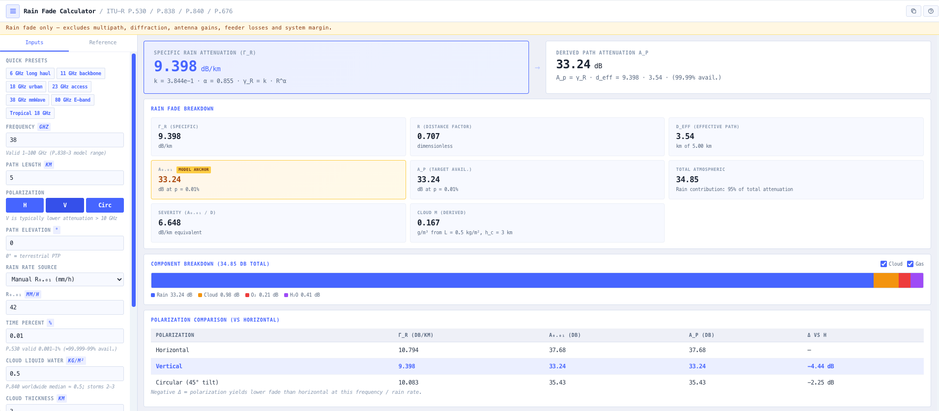
Specific rain attenuation gamma R equals k times R to the power of alpha (P.838). Distance reduction factor r and effective path length d effective (P.530). 0.01 per cent anchor attenuation A 0.01 equals gamma R times d effective. Time percent extrapolation A p derived from A 0.01. Each step shown explicitly so the calculation is reproducible and visibly wrong when something has been entered incorrectly.

Polarisation delta versus horizontal

Side by side horizontal, vertical, and circular polarisation results with the dB delta versus horizontal called out directly. Answers the integrator question how many dB do I gain switching to vertical polarisation at 38 GHz. Uses the full P.838 polarisation blend formula k equals (k H plus k V plus (k H minus k V) times cos squared tau times cos 2 theta) divided by 2 (and similar for alpha) rather than a simplified approximation.

Component breakdown with toggles

Stacked bar of rain, cloud, atmospheric oxygen, and atmospheric water vapour contributions in dB. Toggle cloud or gas off to isolate the rain only number, or on to see why millimetre wave links look so different from microwave. Useful for understanding the real attenuation budget at 26, 38, 60, and 80 GHz where the cloud and gas contributions can dominate the rain at low time percentages.

BOM site lookup for Australian deployments

Latitude and longitude input pulls the nearest Bureau of Meteorology weather station and returns live temperature, pressure, and water vapour density (derived from relative humidity). Falls back to ITU R P.835 standard atmosphere defaults if the station is offline. R 0.01 comes from the P.837 latitude band lookup or manual entry. Source provenance shown alongside the values so the engineering record is traceable.

Frequency sweep with band markers

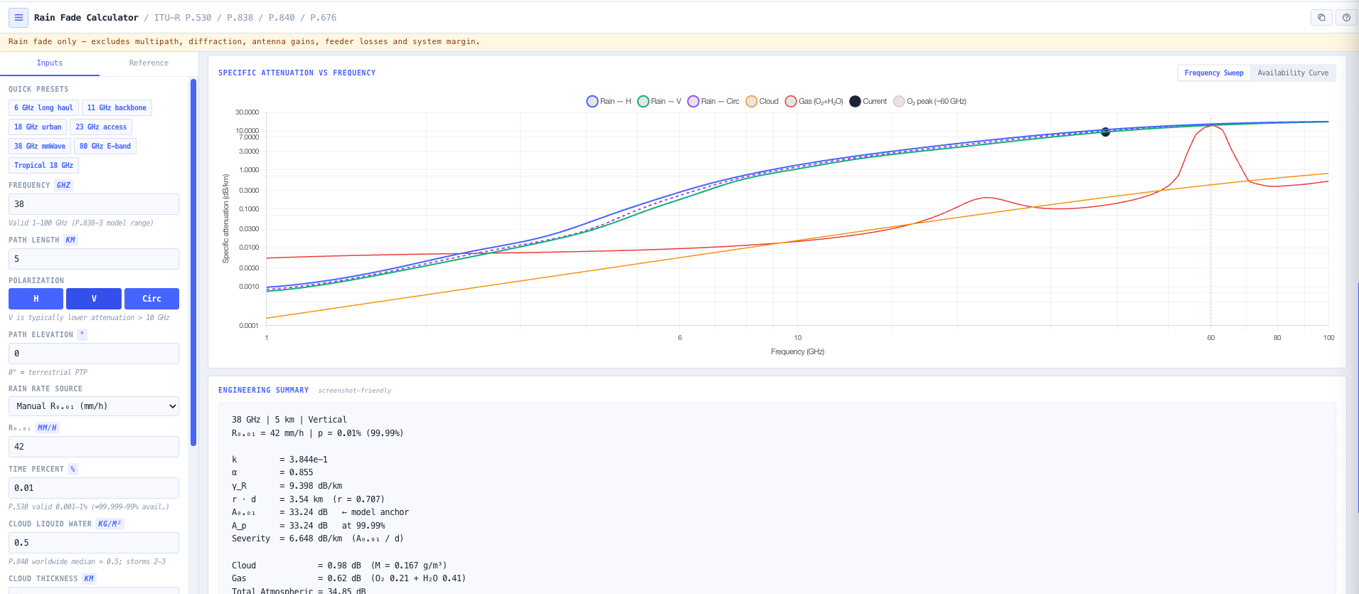
Sweep mode plots gamma R versus frequency from 1 to 100 GHz with horizontal, vertical, and circular polarisation curves overlaid. Standard band markers at 6, 11, 18, 23, 38, 60, and 80 GHz. Cloud and gaseous curves toggleable. Useful for choosing the operating band, understanding why a 38 GHz link is harder than an 11 GHz link in the same climate, and visualising the 60 GHz oxygen absorption line.

Availability curve mode

A p versus time percent on a logarithmic axis, anchored at the P.530 0.01 per cent base. Useful for sizing high availability targets (99.9, 99.99, 99.999 per cent corresponding to 0.1, 0.01, 0.001 per cent unavailability). Extrapolation warning fires for sub 0.001 per cent values where P.530 is at the edge of its validity and the result should be treated with engineering judgement rather than as definitive.

Copy paste engineering summary

One click copy emits a clean engineering snippet covering frequency, path length, polarisation, R 0.01, k, alpha, gamma R, r, d effective, A 0.01, A p, and the rain plus cloud plus gas breakdown. Ready to drop into a design document, project ticket, customer email, or licence application.

Browser only computation

Runs entirely in your browser. No path geometry, climate data, or design parameters are submitted to a server beyond the BOM lookup itself, which is anonymous and does not contain identifying information about the planned link. Useful for commercially confidential infrastructure planning and environments where information security policy prohibits sending engineering data to third party services.

Standards & methodology

  • ITU R P.530. Propagation data and methods for terrestrial line of sight systems
  • ITU R P.838. Specific attenuation model for rain
  • ITU R P.837. Characteristics of precipitation for propagation modelling
  • ITU R P.840. Attenuation due to clouds and fog
  • ITU R P.676. Attenuation by atmospheric gases
  • ITU R P.835. Reference standard atmospheres
  • BOM weather station network for Australian temperature, pressure, and humidity

When to use this tool

  • Quick rain fade sanity check during early microwave or millimetre wave link sizing
  • Choosing polarisation (horizontal versus vertical) for an 18, 23, 38, or 80 GHz path
  • Quantifying total millimetre wave atmospherics (rain plus cloud plus oxygen plus water vapour)
  • Validating a vendor link planning tool against ITU R reference mathematics
  • Sizing availability targets at 99.9, 99.99, or 99.999 per cent
  • Australian site planning with BOM driven temperature, pressure, and humidity
  • Producing rain fade evidence for ACMA microwave licence applications
  • Comparing two candidate operating bands for the same path against rain climate
  • Auditing an inherited microwave link against current rain rate climatology
  • Diagnosing intermittent link availability that correlates with rain events
  • Sizing rain fade margin contribution to the overall link budget
  • Producing teaching examples demonstrating the gamma R, r, d effective chain

Is this the right tool for you?

Reach for the Rain Fade Calculator in any of the following situations.

  • You are sizing the rain fade margin for a microwave or millimetre wave point to point link in tropical, temperate, or arid Australian climate and need a defensible ITU compliant calculation.
  • You are choosing between horizontal and vertical polarisation on a 38 GHz path and need to see the dB delta to justify the polarisation choice in the design record.
  • You are designing a 60 or 80 GHz millimetre wave link where rain is not the only contributor and need to see total atmospherics including cloud and gaseous oxygen and water vapour.
  • You are validating a vendor link planning tool output against the underlying ITU R reference mathematics and need each step in the chain (gamma R, r, d effective, A 0.01, A p) for cross check.
  • You are sizing a high availability target (99.99 or 99.999 per cent) and need the time percent extrapolation from the 0.01 per cent anchor with the P.530 caveat at sub 0.001 per cent.
  • You are responsible for an Australian microwave site and need temperature, pressure, and water vapour density from the nearest BOM station rather than ITU standard atmosphere defaults.
  • You are producing rain fade evidence for an ACMA microwave licence application that requires documented attenuation calculation to ITU references at the operating frequency.
  • You are comparing two operating bands (for example 11 GHz versus 18 GHz, or 23 GHz versus 38 GHz) for the same path against rain climate to inform the band selection.
  • You are auditing an inherited microwave link against current ITU R P.837 rain rate climatology and need to confirm whether the original design rain margin is still valid.
  • You are diagnosing intermittent link availability that correlates with rain events and need to confirm whether the rain attenuation budget is the cause.
  • You are sizing the rain fade contribution to a full link budget and need a clean handoff number (A p in dB) for the link budget sheet.
  • You are training new microwave engineers and want a teaching tool that exposes the canonical ITU chain step by step rather than as a black box.
  • You are responsible for a Pacific Island, South East Asian, or other tropical deployment where rain rate is much higher than Australian temperate climate and need accurate rain fade calculation against the local R 0.01.
  • You are sanity checking a 60 GHz millimetre wave link claim where the molecular oxygen absorption line dominates the budget and need to confirm gas attenuation specifically.
  • You are operating under a security regime that prohibits sending design data to third party services and need a rain fade calculator that runs entirely in your browser.

Frequently asked questions

What ITU recommendations does the calculator use?

P.530 for path scaling and time percent extrapolation. P.838 for specific rain attenuation gamma R equals k times R to the power of alpha. P.837 for rain rate climatology by latitude band. P.840 for cloud attenuation. P.676 Annex 2 for gaseous oxygen and water vapour attenuation. P.835 for reference standard atmosphere when local data is not available. Each calculation step is annotated with the ITU reference used.

How is rain rate R 0.01 chosen?

Three ways. Manual entry when you have a measured local rain rate climatology. ITU R P.837 latitude band lookup which provides reasonable defaults for any location globally. BOM site lookup for Australian deployments which pulls the nearest weather station and returns climatology data with provenance. R 0.01 is the rain rate exceeded 0.01 per cent of the time, which is the standard P.530 anchor.

How does polarisation affect rain attenuation?

Vertical polarisation typically experiences less rain attenuation than horizontal because raindrops are flattened by aerodynamic drag during fall and present a smaller projected cross section to vertically polarised waves. The effect grows with frequency and rain rate. At 38 GHz with heavy rain the delta can be 1 to 2 dB. Circular polarisation falls between H and V. The calculator uses the full P.838 polarisation blend rather than a simplified approximation, with the H, V, and circular results displayed side by side.

How is path scaling handled?

P.530 specifies a distance reduction factor r that accounts for the fact that heavy rain cells are localised. The actual path attenuation is gamma R times d effective, where d effective equals r times d and r is less than 1 for paths longer than the typical rain cell size. This corrects against using the full physical path length, which would over predict attenuation. The calculator returns r and d effective explicitly so the correction is visible.

Why does cloud and gas matter at millimetre wave?

At 6 to 11 GHz, rain dominates the atmospheric budget. At 18 to 23 GHz, water vapour absorption starts to contribute meaningfully. At 38 GHz, both cloud and water vapour are non negligible additions on top of rain. At 60 GHz, the molecular oxygen absorption line dominates (15 dB per km even in dry air at sea level). At 80 GHz, the budget is rain plus water vapour plus oxygen all contributing significantly. The component breakdown surfaces each one separately so the design discussion targets the dominant contributor.

How is availability extrapolated from the 0.01 per cent anchor?

P.530 provides a time percent extrapolation function that scales the 0.01 per cent attenuation to other percentages. A p equals A 0.01 times 0.12 times p to the power of (minus (0.546 plus 0.043 log p)) for p in per cent. Valid from 0.001 to 1 per cent. Below 0.001 per cent (corresponding to availability above 99.999 per cent) the extrapolation enters the validity edge and the calculator surfaces a warning. The result is still useful as a guide but should be treated with engineering judgement rather than as definitive.

How does this support the noIM₃ Link Planner?

The Rain Fade Calculator is the focused single point analysis tool for rain fade and atmospheric attenuation. The noIM₃ Link Planner is the full ITU anchored RF planning workstation with terrain accurate path profiles from Mapbox global Terrain RGB DEM, automatic ITU P.526, P.530, P.676, P.838, P.840, P.2108 model coverage, Fresnel zone clearance, multi link projects, and full provenance for every input. Use the Rain Fade Calculator for fast sanity checks and individual band trade off studies. Use the Link Planner for full microwave link design and ACMA submissions.

Does any data leave my browser?

The calculation itself runs in your browser. The optional BOM lookup queries the Bureau of Meteorology weather station network anonymously to retrieve temperature, pressure, and humidity for the configured coordinates. No identifying information about the planned link or design is transmitted. Useful for commercially confidential infrastructure planning where the calculation must stay local but climatology data can be retrieved openly.